First & Grandview District Plan
Building Inventory and Evaluation (2025)
Introduction
In early 2025, the Grandview Heights/Marble Cliff Historical Society (GH/MCHS) completed an inventory and evaluation of buildings located in the First & Grandview District, an area that is the focus of ongoing planning efforts by the City of Grandview Heights. Please see the attached map showing the planning district boundaries.
The inventory is not a comprehensive survey of all buildings within the district boundaries; rather, the focus is on 18 buildings identified as “private redevelopment opportunities” in the City’s recently-adopted First & Grandview District Plan, as shown on the attached map. The entire plan may be viewed at https://growingtogether.grandviewheights.gov/planning-first-grandview-district-plan.
This material is intended to provide the City of Grandview Heights and its citizens with pertinent information about these buildings so that their historic and architectural value to the community may be taken into account as decisions are made. Each building is documented on an inventory sheet that includes a current photo and map, architectural description, historical information, and historic maps. In addition, each building is given a ranking using professional standards for evaluating significance in the context of the First & Grandview District, its character and its history. The 18 inventory sheets are attached to this report.
Historic Context/Patterns of Development
The First & Grandview District plays an important role as the historic commercial and civic center in the City of Grandview Heights. Historic maps from 1910 through 1961 (listed in Resources, below) were used to shed light on the overall historic patterns of development for this district.
Commercial development began, in fact, on West First Avenue, as this was the route for the “Arlington Line,” the streetcar from downtown Columbus established in 1901 to serve the developing Tri-Village areas of Grandview Heights, Marble Cliff, and Upper Arlington. The intersection of Oakland and West First Avenues became a commercial node as early as 1895 when a building housing Arnold’s Grocery Store existed there. In 1910, West First Avenue contained a small number of buildings and the surrounding residential streets were sparsely built up. Grandview Avenue still remained largely undeveloped. At that time, the intersection of Grandview Avenue and West First Avenue was the location of the Salzgaber family’s produce farm, established there in the late 1800s. Importantly, the 1904 Salzgaber farmhouse still exists at the northeast corner of West First and Grandview Avenues, a reminder of the area’s origins.
By 1922, Sanborn Insurance Company Maps show that the two blocks of West First Avenue between Fairview and Ashland (the route of the streetcar) had become a commercial node, with 15 stores housing a variety of businesses in eight buildings. Only two of those buildings remain standing today (1628-1634 and 1668-1670 West First Avenue). Grandview Avenue was not yet commercial with the exception of the Masonic Building at the northwest corner of First and Grandview Avenues, constructedin 1922. In addition to its use as a fraternal hall, the Masonic Building contained commercial storefronts along both Grandview and First Avenues. The only buildings on the west side of Grandview Avenue at that time were the three houses that still exist today (1217, 1229 and 1237 Grandview Avenue). The earliest of these (1237 Grandview Avenue) was built in 1916 by the Salzgaber family.
Grandview Avenue began to develop commercially during the late 1920s, with construction focused on the west side of the street to the north of West First Avenue. The Grandview Theater was built in 1926, followed by the 1927 construction of the Bank Block, recognized as an early “shopping center” development that is today listed on the National Register of Historic Places. The Bank Block contained a variety of storefronts, offices in its second-floor sections, and convenient off-street parking at the rear. Some occupants of earlier buildings, such as the Piggly Wiggly store that was originally located at 1634 West First Avenue, relocated to the Bank Block upon its completion. At about the same time, three one- story brick buildings, each containing two storefronts, filled in the vacant lots to the west and north of the Masonic Building, providing more options for small businesses. These were built in 1926 (1516-1520 West First Avenue and 1241-1243 Grandview Avenue) and 1928 (1221-1223 Grandview Avenue). In combination with the Bank Block, these buildings provided goods and services for Grandview Heights residents to the present day. Not surprisingly, some of the business owners who occupied the Bank Block and other district commercial buildings lived in houses nearby (including the proprietor of Long’s Pharmacy, who resided at 1462 W. Second Avenue, and the owners of Young’s Bakery, who lived at 1229 Grandview Avenue.)
The 1930s saw the addition of a dedicated space for the Grandview Heights Public Library on West First Avenue, built in 1936. The Grandview Medical Building at 1620 West First Avenue was a unique addition to the streetscape when it was built in 1938. Faced in yellow brick, this two-story building represented a departure from the frame or red brick buildings that preceded it. It housed both physician’s offices and apartments. In 1955, the Grandview Apex Market building was built further to the west at 1660 West First Avenue, replacing a filling station on the site. Set back from the street, this store provided parking in front of the building, a common practice today that was just beginning at the time. Finally, commercial buildings in the district from the 1960s include office buildings located at 1621 and 1635 West First Avenue, constructed in 1961 and 1960, respectively, and the former Ohio National Bank, built in 1964 at 1530 West First Avenue. These buildings introduced mid-century trends in architecture to the area.
Levels of Significance
Professional standards used to evaluate significance for this inventory are drawn from criteria developed by the National Park Service for conducting inventories of historic properties within a local context. (Reference www.nps.gov/articles/sec-stds-evaluation-guidelines.) Factors considered for this particular inventory include:
• age (generally 50 years and older);
• design that is representative of a style or building type that was historically found within the district;
• architectural integrity (would the original builder recognize it today?);
• association with individuals or groups of people important in history; and• representation of patterns of events important in history.
For the purpose of this inventory, the 18 buildings are evaluated solely within their local historic context. They are not compared with buildings in other communities, but considered only in the context of the First & Grandview District and its development over time.
Level 1 (Significant Buildings)
These buildings display characteristic features illustrating an architectural style, building type, or time period and method of construction that was important to the development of First Avenue and Grandview Avenue over time. These buildings may be associated with events, businesses, or individuals that played an important role in the community. They display architectural integrity and quality in their design and materials.
Grandview Avenue:
• 1217 Grandview Avenue – built 1921 or 1922, an example of early residential development on Grandview Avenue. Long-time home of the Jennings family, whose daughter Ellen Jennings became a noted local sculptor.
• 1221-1223 Grandview Avenue – intact 1928 commercial building with two storefronts, distinctive Craftsman elements remain in the design.
• 1237 Grandview Avenue – built 1916 by Charles Salzgaber for his son Clarence. The Salzgaber family is locally important for the vegetable truck farm that was historically located on this land. The house retains its architectural character.
• 1462 West Second Avenue – built 1925, an intact example of the Bungalow residential building type, was the home of J. Robert Long, owner of Long’s Pharmacy in the Bank Block, a popular local hangout in the years before and after World War II.
West First Avenue:
• 1516-1520 West First Avenue – built 1926, early brick commercial building typical of the period, distinctive design, intact storefronts.
• 1530 West First Avenue – built 1964 for Ohio National Bank, example of updated banking facility with modern conveniences (moved here from the Bank Block). The building was designed with International Style architectural elements.
• 1620 West First Avenue – built 1938 as the Grandview Medical Building, with medical offices on 1st floor and apartments on 2nd floor. Noted early female physician Dr. Grace Brown had her office here from 1938-1962.
• 1628-1634 West First Avenue – built 1922-23, early brick commercial building typical of the period, distinctive brickwork, compatible modern storefronts. Original location for Piggly Wiggly grocery story before relocating to the Bank Block in 1927.
Level 2 (Contributing Buildings)
These buildings retain characteristic features of their style and period of construction, but have a lower
level of architectural significance or integrity. These simpler and more vernacular buildings neverthelesscontribute to the historic character of Grandview Heights and illustrate the City’s development over time.
Grandview Avenue:
• 1241-1243 Grandview Avenue – built in 1926, an example of a small-scale commercial building with two storefronts, home to the Kroger Company until 1928 and a variety of businesses through the years. Some alterations to the façade.
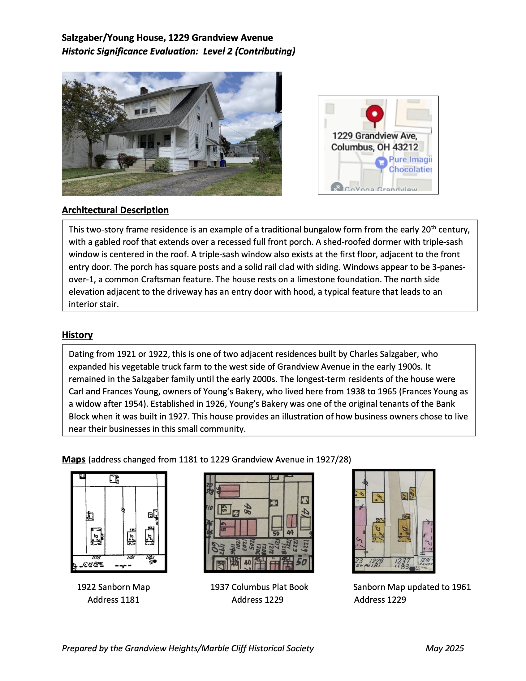
• 1229 Grandview Avenue – built in 1921 or 1922 by the Salzgaber family, historically important as early residents who owned the vegetable truck farm that was located on this land.
West First Avenue:
• 1627-1629 West First Avenue – built 1925, early brick commercial building with some alterations to the façade, location of a long-time business, the Foettinger Fur Store, from 1936 to 1970.
• 1621 West First Avenue – built 1961 and occupied for many years by Kellam & Foley Architects. Firm had started in a house on W. First, and likely built this building. An example of Mid-Century Modern with the style mostly evident on the east-facing elevation containing the entrance.
• 1635 West First Avenue – built 1960 as a small office building with intact Mid-Century Modern elements at the façade.
• 1660-1666 West First Avenue – built 1955 and occupied by the Grandview Apex Market, a grocery store until the 1990s. Simple building, provided parking in front (important to the period) and retains integrity.
Level 3 (Non-Contributing Buildings)
These buildings were very recently constructed, or are older with significant alterations causing them to lack architectural integrity.
Grandview Avenue:
• 1276 Grandview Avenue – built 1987-1988, this is modern construction that was the third addition to the Spencer Research complex on Grandview Avenue.
West First Avenue:
• 1510 West First Avenue – built 1920-21 as a residence, character is altered by major additions to the front and side, an example of a residence transitioning to commercial use in the 1940s and 1950s.
• 1668-1670 West First Avenue – built c. 1920, two storefronts, simple building but little remains of its historic appearance.
• 1200-1230 Oakland Avenue – modern condominiums, built 2003
Sources
Columbus City Directories, available at the Columbus Metropolitan Library, multiple years
Baist Real Estate Atlas for Columbus, Ohio, 1910
Sanborn Insurance Company Maps, 1922, 1951, 1961
Plat Book of Columbus and Vicinity, Franklin County, Ohio, 1937
Grandview Heights/Marble Cliff Historical Society website: https://www.ghmchs.org/
The Columbus Dispatch, digital archives accessed through the Columbus Metropolitan Library website
Helpful Resources
First & Grandview District Plan
The First & Grandview District Plan adopted by the City of Grandview Heights can be viewed by visiting https://growingtogether.grandviewheights.gov/planning-first- grandview-district-planGrandview Heights/Marble Cliff Historical Society website
Historic information about the City of Grandview Heights and the Village of Marble Cliff can be found here.Design Guidelines for Historic Properties
The City of Grandview Heights has adopted design guidelines to assist in the preservation and rehabilitation of historic properties in the community. These guidelines may be accessed on the City of Grandview Heights’ website: https://www.grandviewheights.gov/DocumentCenter/View/8673/Design-Guidelines-2024
The historic building inventory and evaluation was prepared by Judy Williams, Grandview Heights resident, GH/MCHS Trustee, and historic preservation consultant. Please direct any questions or comments to Judy via email: ghmchs@gmail.com.
Society’s Historic Inventory and Evaluation

Map from the City’s First & Grandview District Plan identifying location of proposed redevelopment sites